The Tri-State Mining District (TSMD) spans 2,500 square miles of southwest Missouri, southeast Kansas, and northeast Oklahoma. From the late 1800s through the mid-1900s, it was one of the largest lead and zinc mining areas in the world. At its peak, the district fueled industrial growth and wartime production, providing materials essential for batteries, paint, ammunition, and construction.
When the mines closed in the 1970s, they left behind a lasting legacy of waste piles, abandoned shafts, and contaminated land and water. Today, the region faces ongoing environmental and health challenges tied to its mining past.
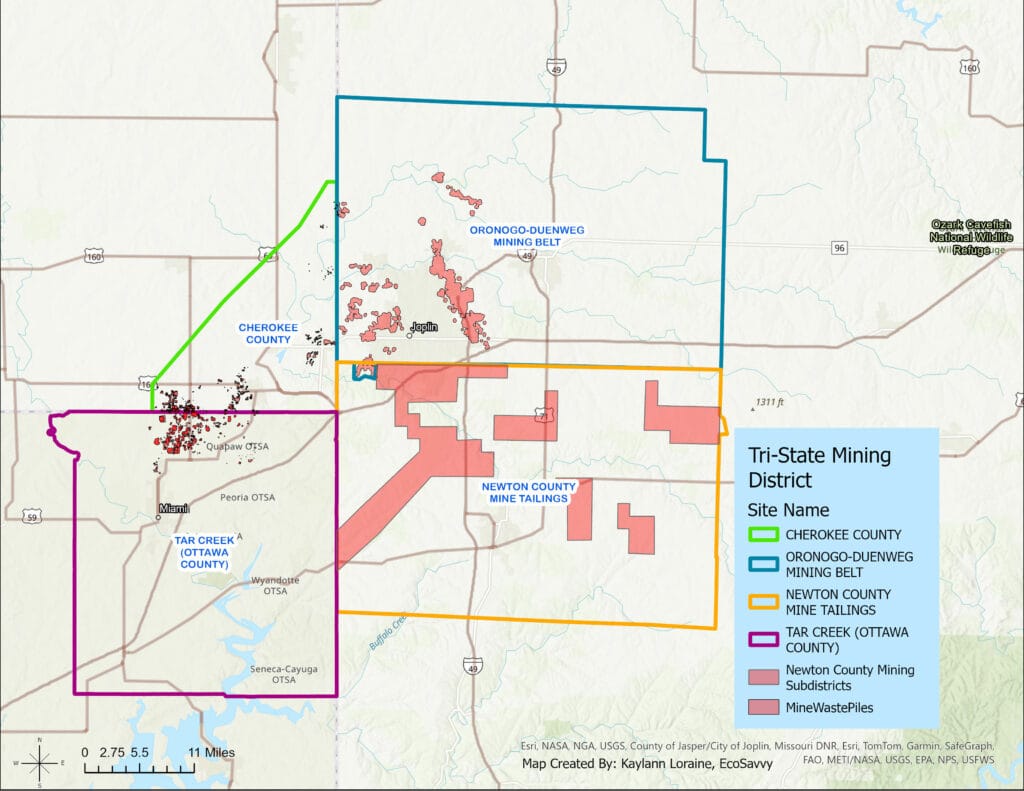
Superfund Sites in the Tri-State Mining District
Missouri (Jasper & Newton Counties)
- Oronogo-Duenweg Mining Belt Superfund Site (Jasper County, MO)
- Covers 7,000 acres around Joplin, Webb City, Carterville, and Oronogo.
- Over 10 million tons of contaminants: primarily lead, zinc, cadmium in soil, water, and chat piles.
- Cleanup has focused on replacing contaminated residential soils and managing chat piles.
- Newton County Mine Tailings Superfund Site (Newton County, MO)
- Includes Granby and surrounding areas.
- One of the oldest mining areas (lead smelting began in the mid-1800s).
- Major cleanup efforts include soil replacement and water quality monitoring.
Kansas (Cherokee County)
- Cherokee County Superfund Site (KS)
- Covers six sub-sites across Galena, Baxter Springs, Treece, and surrounding areas.
- Contaminants: lead, zinc, cadmium in soil, groundwater, and surface water.
- Chat piles and mine waste were widespread; some removed, others stabilized.
Oklahoma (Ottawa County)
- Tar Creek Superfund Site (OK)
- Includes Picher, Cardin, Commerce, North Miami, and Quapaw tribal lands.
- One of the most famous and complex Superfund sites in the U.S.
- Problems include:
- “Chat” mountains across the community.
- Acid mine drainage turning Tar Creek orange.
- Severe lead exposure in children.
- Picher and Cardin became ghost towns after buyouts due to contamination and subsidence risks.
Environmental & Health Impacts
- Soil contamination: Lead and zinc tailings were often spread as gravel on roads, driveways, and playgrounds. Many residential yards still have unsafe lead levels.
- Water contamination: Abandoned mines released polluted water into local streams and rivers, impacting fish and aquatic life.
- Air quality: Dust from chat piles can carry lead and other metals.
- Human health: Lead exposure is especially dangerous for children, causing developmental delays, behavioral problems, and long-term neurological damage.
Cleanup Efforts
The U.S. Environmental Protection Agency (EPA) designated large parts of the district as Superfund sites in the 1980s. Cleanup efforts include:
- Replacing contaminated residential soils with clean soil.
- Removing or capping chat piles.
- Treating polluted water from mine shafts.
- Ongoing testing and monitoring of homes, schools, and waterways.
Despite decades of work, cleanup remains complex and incomplete due to the scale of contamination.
Lasting Community Impact
The mining district’s legacy continues to affect communities today. Redevelopment projects, land reuse, and even basic public health require ongoing attention to past contamination. Residents, local leaders, and environmental organizations continue to work toward a healthier, safer future.
Learn More
Tri-State Mining District Watershed
TAR CREEK (OTTAWA COUNTY) OTTAWA COUNTY, OK
NEWTON COUNTY MINE TAILINGS NEWTON COUNTY, MO